

Figure 1. Emlagh East Ogham stone, Dingle Peninsula
I. Introduction
Ogham stones are among Ireland’s most remarkable national treasures. These perpendicular cut stones bear inscriptions in the uniquely Irish Ogham alphabet, using a system of notches and horizontal or diagonal lines/scores to represent the sounds of an early form of the Irish language. The stones are inscribed with the names of prominent people and sometimes tribal affiliation. These inscriptions constitute the earliest recorded form of Irish, and, as our earliest written records—dating back at least as far as the fifth century A.D.—they are a significant resource for historians, as well as linguists and archaeologists.[1]
The School of Celtic Studies at the Dublin Institute for Advanced Studies (DIAS) is home to a very successful Digital Humanities project in the area of Irish Studies: Irish Script On Screen (ISOS), which digitizes Irish manuscripts and makes high-quality images available online. Inspired by the way ISOS makes these important, predominantly Irish-language resources available worldwide, the Ogham in 3D project, also based at the School of Celtic Studies, aims to do the same for Ogham inscriptions on stone, our earliest written Irish sources. However, whereas high quality 2D images are well-suited to capturing manuscripts, the nature of Ogham inscriptions requires an extra dimension. Unlike most epigraphy, which is found on the face of the stone, and so is relatively easy to capture in a photograph, Ogham inscriptions are generally located on one or more angles/edges, using the natural edge/arris of the stone as a stem-line for the scores and notches that make up the Ogham alphabet. Therefore, it frequently happens that a photograph fails to show the complete inscription, as in the case of the photograph below (Figure 2a) of one of the Ardmore Ogham stones, in which only part of the inscription, covering three angles, can be seen. Paired with this photograph is one potential way around this problem: a drawing by R. A. S. Macalister (Figure 2b) that attempts to represent the whole inscription in 2D.[2]

Figures 2a and 2b. One of three Ogham stones discovered at Ardmore, Co. Waterford.
Certainly accurate drawings of the stones and their inscriptions such as Macalister’s are very useful. However, with a rotating 3D model, you get a much more accurate representation of the stone and its inscription, along with any extra features which may occur, such as a carved cross.
II. Previous Research
Seminal work has already been carried out on Ogham, most notably, from a linguistic perspective, by Professor of Early Irish at Trinity College Dublin and author of A Guide to Ogam (1991), Damian McManus and, from an archaeological perspective, by Senior Archaeologist at the National Monuments Service, Fionnbarr Moore. To date, the Ogham inscriptions have been recorded using drawings and conventional photography. Tribute must be paid to the pioneering work of R.A.S. Macalister, who, as noted above, produced line drawings of remarkable clarity in his Corpus Inscriptionum Insularum Celticarum (1945). It is also important to recognize the work done by Jost Gippert in digitizing color slides of many of the Ogham inscriptions in his online project, Thesaurus Indogermanischer Text- und Sprachmaterialien. Some of the materials from Gippert’s project have been reproduced in a most useful CD-ROM produced by Fios Feasa (2002), with the inclusion of some additional photographs.
The Celtic Inscribed Stones Project (CISP) also includes many of the Ogham stones in its online database. The Ogham in 3D project focuses exclusively on Ogham stones, bringing all of the available information together in a single searchable website and adding an innovative dimension to the work already carried out in the form of 3D models of the stones. In the following paragraphs, I hope to give you an idea of what is involved in a multidisciplinary Digital Humanities project like ours—the challenges and achievements that make working in (Medieval) Irish Studies all the more rewarding.
III. Ogham in 3D: Aims and Objectives
The idea for the project—using 3D laser scanning to record Ogham inscriptions—originally came from Professor Werner Nahm, Director of the School of Theoretical Physics at DIAS. He approached Professor Fergus Kelly in the School of Celtic Studies, and together they organized a conference in 2008 to assess the feasibility of an Ogham in 3D project.
The aims of the resulting Ogham in 3D project are:
• firstly, to use 3D technology to capture Ogham inscriptions in greater detail before further deterioration from weathering and vandalism results in their permanent loss
• secondly, to use this 3D data to assist in the reading of problematic inscriptions, to inform conservation policy through deviation analysis, and to analyze carving techniques and tools used
• thirdly, to digitally reconstruct, where possible, broken Ogham stones from the 3D data (for example, Monataggart CIIC119), which would also facilitate the creation of replicas of the stones if ever required
• and finally, to make information on Ogham inscriptions/stones/sites more accessible to researchers, schools, and the general public by developing a comprehensive, searchable Ogham website including descriptions, photographs, maps, and 3D models of the stones
The current phase of the project, which focuses on Ogham stones in state care under the supervision of the National Monuments Service, is funded by the Department Arts, Heritage, and the Gaeltacht. In October 2012 work began on this phase in collaboration with The Discovery Programme whose expertise in 3D capture and modelling is proving invaluable to the project. The project website, https://ogham.celt.dias.ie, was launched by Minister Jimmy Deenihan in May 2013 and currently has 110 digitized Ogham records out of an approximate 400 known Ogham stones (mainly in Ireland, but also in significant numbers in Wales, the Isle of Man, Devon and Cornwall, and Scotland, although most of the Scottish Oghams appear to be in Pictish or Old Norse). The Ogham in 3D website also includes links directly to the equivalent Ogham record in the National Monuments Service’s Archaeological Survey Database (ASI).
IV. Methodologies
The work of the project involves a combination of office-based multidisciplinary research and field work, primarily in the form of 3D scanning. Research on the various aspects of each Ogham stone and site is initially carried out, followed by onsite 3D scanning of the Ogham stones and, where appropriate, the site/context. The final stage involves the processing of the 3D data and the encoding of the data on each stone in XML in preparation for the website.
a. 3D Scanning
In order to capture the 3D data for the stones, we collaborate with 3D experts at The Discovery Programme, an institute for advanced research into Irish archaeology and related matters. 3D data capture of Ogham stones is most often accomplished using a handheld laser scanner,[3] which combines flexibility, speed, and high-resolution capture (0.2mm point spacing). An original Polhemus FastSCAN Cobra was replaced last year by a more advanced Artec Eva 3D scanner purchased by the Discovery Programme specifically for the Ogham in 3D project. An additional feature of the Artec Eva is its ability to also capture texture or color (RGB). Although untextured data—a shaded surface wrap—is preferable for analyzing the inscriptions, textured models work well for presentation purposes, such as for display on the website. The remote location of many of the Ogham stones presents logistical challenges that are not normally experienced with object scanners—generally this work is done in the controlled environment of a laboratory. The scanner (and laptop to operate it) requires a reliable source of electricity, and so a portable generator needs to be included on field work. Certain conditions are required for good quality results: the surface of the stone needs to be dry, and light must be excluded, as the scanner is highly sensitive to daylight. Additionally, the scanner, laptop, and generator need to be kept dry—which can be quite a challenge with our unpredictable Irish weather! For this reason, a forensic blackout tent is part of the standard equipment on site, controlling the light and keeping everything dry (see figure 3 below).
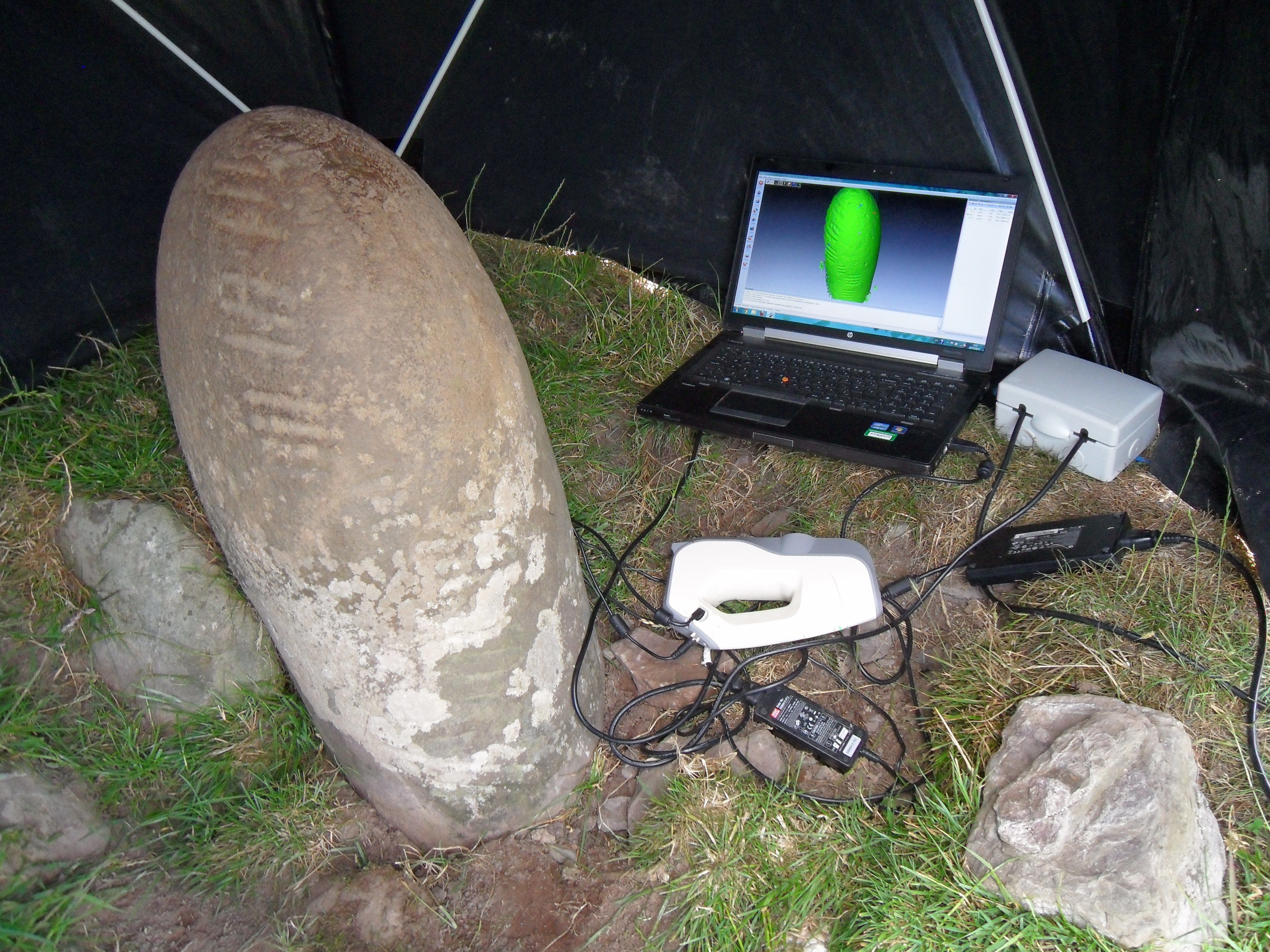
Figure 3. Artec EVA field work set up at Lugnagappul, Dingle Peninsula
As mentioned previously, in some cases, scanning the site of the Ogham stone is also undertaken. Ogham stones are frequently found in isolation and seemingly unassociated with any other archaeological feature. However, a high percentage of Ogham stones are found at or near early church sites. They are also often found reused, predominantly in souterrains. In these cases, particularly where numerous archaeological features survive, we use a terrestrial scanner (a Faro Focus 120) to capture the entire site and thus place the Ogham stone in the context of its surroundings (whether original or secondary). Video flythroughs of these surveys can then be generated and added to the website.
The Faro scanner is also occasionally used to scan Ogham stones that are too large for capture with the handheld scanner, as was the case, for example, with the Knickeen Ogham stone, Co. Wicklow. However, this method is only successful where the inscription is quite clear. In cases where high resolution is required to accurately record and later analyze the inscription, an alternative method of 3D capture is required. In 2013 we also began testing a technique called Structure from Motion (SfM), which uses high-quality, precisely taken photographs to generate 3D models (see figure 4 below). A further benefit to this method of 3D capture is that a good digital camera and the processing software are the only equipment required.
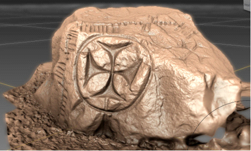
Figure 4. 3D model screenshot of Ogham stone at Kilcolman church site (Maumanorig, Dingle Peninsula) generated using Structure from Motion
b. Encoding
At the Ogham in 3D project, we use the EpiDoc Guidelines, a subset of the Text Encoding Initiative’s standard for XML developed for use by epigraphers. The guidelines are a detailed collection of suggested conventions for encoding epigraphic texts that embodies the collective wisdom of a group of practicing epigraphers and XML specialists. Apart from the fact that EpiDoc has been designed specifically for digitizing inscriptions, the advantage of using these XML guidelines is the support provided by the EpiDoc Collaborative. This is an international community of scholars working with texts, primarily in ancient Greek and Latin, inscribed on durable materials (principally stone). Many of the issues surrounding the guidelines are equally relevant to scholars working with other ancient and medieval texts, such as Ogham.
c. User Interface and Feedback
The Ogham in 3D website is still in the relatively early stages of development and any feedback would be most welcome. In particular, we are keen to develop the website as a useful resource for research and teaching, as well as an informative guide for anyone interested in finding our more about Ogham. Therefore, in addition to the ability to browse the Ogham stones by location, the Ogham inscriptions are also so far searchable by personal and tribal names, by formula words found in the texts (such as MAQI, meaning “son of”), by the site types at which they are found, by specific carving techniques used, by the occurrence of a carved cross on the stone and by a relative chronology of linguistic features following McManus’s A Guide to Ogam[4] (as well as by any combination of these). The 3D models of the stones are made available on the website primarily in PDF format (including some examples of textured models), which allows both for manipulation of the model (such as rotation, zooming, and lighting, among others) as well as for measurements to be taken. We also make the larger (and higher resolution) .OBJ files available for those who have appropriate software. In addition, we have recently started to use an embedded 3D model viewer by Sketchfab, which is probably the best online, 3d visualization method available at the moment.
We are now at the stage of collecting 3D data and carrying out multidisciplinary research on each of the Ogham stones. We have decided to go live with the website at this early stage so that the general public can follow our progress and become involved in the project. We also have a Facebook page, which we use to inform our followers of new additions to our website, field work activities, and so on. We have had wonderful feedback, including a number of reports of possible previously unrecorded Ogham stones.
V. Future Directions
Once the 3D data has been collected, our long-term plans—funding permitting—include analysis of the 3D data to assist with difficult readings and to monitor erosion of the stone. While the available 3D models are already allowing us, as well as anyone who visits the website, to review previous readings of the inscriptions (often in unfavorable lighting conditions in the field), analysis of the 3D data has the potential to reveal worn inscription no longer clear to the naked eye. It would also be possible to analyze the various carving techniques to determine if any distinctive patterns can be found. In the meantime, we are carrying out a pilot carving analysis of a selected number of Ogham stones with the assistance of a sculptor, to distinguish the various techniques and tools used by careful examination of the stones themselves. The finished report, including a video showing how the Ogham inscriptions may have been carved, will be added to the website later this year.
VI. Conclusions
As the Ogham in 3D project has developed, it has increasingly embraced open-source alternatives and approaches. From the outset, a decision was made to use XML encoding allowing for compatible, transparent, and easily manipulated data. We use Open Street Maps as a default, and our work is licensed under a Creative Commons Attribution-NonCommercial-ShareAlike 3.0 Ireland License. We have recently taken the initial steps to become involved in a new Europe-wide project called LoCloud, overseen by our partners at the Discovery Programme. LoCloud will support small and medium-sized institutions in making their content and metadata available to Europeana (the European Digital Library of Culture), by exploring the potential of cloud-computing technologies. We are already in a good position for this involvement, since, as previously mentioned, our data is in XML format.We have also begun discussions with the Digital Repository of Ireland (DRI) with a view not only to supplying copies of our data to their repository but also to collaborating on their Location LODer project.[5] We are planning for the future of Ogham in 3D by preparing for Horizon 2020 European funding, the next step of which is to identify and communicate with possible collaborators in other European countries in the area of Cultural Heritage utilizing digital technology.
In this digital age we have the opportunity to digitally preserve our monuments and bring them to the attention of the wider public, both at home and abroad, both now and into the future. The digital shift is also transforming the shape of the knowledge that we will transmit to future generations as our legacy. Digital cultural resources have the potential to promote creativity and generate innovation in research, leading to richer interpretations of the past and bringing new perspectives to questions of identity and culture. Larger institutions such as the Smithsonian are fast realizing the benefits of digitization and the use of 3D technology. On a much smaller scale, I hope that the Ogham in 3D project will continue to have a part to play in this endeavor and ensure the appreciation and preservation of these precious national and international monuments.
[1] This article incorporates some text from our website.
[2] R.A. S. Macalister, Corpus Inscriptionum Insularum Celticarum (Dublin: Stationary Office, 1945), 259.
[3] Also referred to as “object” scanners, and as opposed to “terrestrial” scanners, which have less flexibility and lower resolution (maximum 1-2mm), and thus are more suited to capturing larger areas such as buildings.
[4] Damian McManus, A Guide to Ogam, Maynooth Monographs 4, (Maynooth: An Sagart, 1991).
[5] The Location LODer demonstrator website gives an interactive introduction to the potential of the Linked Logainm concept. Linked Logainm data and a Google Maps interface to allow users to explore content from a range of digital resources relating to locations across Ireland.